

we figured out very quickly that Death Valley,
much like Yellowstone,
has a lot of beautiful sights. . .
with a whole lot of nothing
but highway and desert in between. . .

but always, always beautiful views in every direction. . .
much like Yellowstone,
has a lot of beautiful sights. . .
with a whole lot of nothing
but highway and desert in between. . .

but always, always beautiful views in every direction. . .
Dante’s View. . .1600 feet above the desert floor. . .

this scene to me. . .epitomizes Death Valley
the salt flats . .the desolation. . .the barrenness. . .
and yet. . .in all that. . .the beauty!

and in the distance. . .across the valley. . .
beautiful, snow covered, Telescope Peak. . .summit 11,331 ft. . .
located in the Panamint Range. . .just gorgeous

several great hiking trails located at the top. . .
Furnace Creek was our next major stop. . .
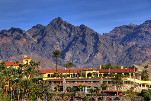
this is the Furnace Creek Inn. . .
what I would consider an oasis in the desert. . .
also located at Furnace Creek is the Visitor Center. . .
several cafes. . .a grocery store (very ouchy prices)
restrooms. . .one of the three RV parks in the park
that have hookups (plan for in advance)
we didn’t plan well. . .and no reservations were available. . .
next planned stop. . .Scotty’s Castle. . .
only. . .we realized we had goofed off too long,
and that by the time we drove all the way there. . .
did the tour (2 hours) saw the surrounding area,
and drove back, we were going to be pushing dark
with a 70 mile trip back to the RV Park. . .
revamp. . .focus on the rest of the park,
and save Scotty’s Castle for next time. . .
you gotta do what’cha gotta do. . .

the Mesquite Flat Sand Dunes are beautiful. . .

the desert in bloom overlooking the salt flats

was just gorgeous. . .
Everything about the 20 Mule Team Borax
mining operation was fascinating. . .


from seeing the original Borax wagons. . .

to driving through the 20 Mule Team Canyon. . .

to what’s left of the mining operation. . .


then on to Devil’s Golf Course
where, after a bit of moisture, you can see
the salt crystals forming on the surface. . .
these little piles of salt are hard as rock
and sharp as glass. . .not a great place to be walking around. . .
Now. . .off to the lowest point in the United States. . .

The Badwater Basin
our Rand McNally GPS said we were –308 below sea level. . .
but I guess we’ll trust the engineers who determined
it to be –282 feet. . .and a very, very warm 88*
that “dry heat” felt like baking in an oven. . .LOL!

I called this the “Salt Highway”

100’s of folks out there walking on it. . .


and amazing enough. . .a pool of water

down amongst the salt flats

entering Artist Drive. . .
I’m sure the entire area is even more beautiful
in the early morning or late afternoon sun. . .
 “
“”Artist Palette” aptly named. . .
so many different colors. . .
you need to see it for yourself

and our last stop of the day. . .Zabriskie Point. . .
the “Badlands” of Death Valley. . .


a really wonderful day. . .
another one of those amazing places
that pics do no justice . . .
We are so glad we saw it. . .
and must insist that you add it to your list. . .
See you next time in Los Angeles,
where we have no clue what we are actually going to do or see. . .
A Gray Line Hop On – Hop Off Bus Tour is on the agenda. . .
we’ll decide from there. . .should be interesting. . .
’til then,
Janice and Dave

No comments:
Post a Comment